GTPR- 2-Shames to Carnaby
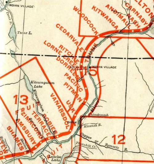
Grand Trunk Pacific Railroad
Shames Station
Shamos Station (in 1911 list) simple typo error?
78 mi from Rupert,
Elevation- 103 ft above sea level
1669.2 miles from Winnipeg
(Located at Mile 75.31 in 1911)
Latitude- 54º 25' N, Longitude- 128º 56' W
Flag Station
Native Village shown in this location in 1910 map
Lakelse Station (in 1911 list)
Located at mile 82.30 in 1911
Amsbury Station
85 mi from Rupert,
Elevation- 151 ft above sea level
1661.1 miles from Winnipeg
Latitude- 54º 28' N, Longitude- 128º 46' W
Zimacord
Zymagoitz River (Water)
Elevation- 156 ft above sea level
1659.0 miles from Winnipeg
Kitsumgallum River (Kalum River)(Water)
Mouth of the Kalum River
Kitsumkalim - Kitsumkalum - Kitsum
Elevation- 183 ft above sea level
1656.0 miles from Winnipeg
Kitsum Station in 1911 list
(located at mile 88.36 in 1911)
Kitsumkalum
Originally submitted to be called Kitsumkallum station in 1911, but shortened to Kitsum Station, by the GTP Telegraph staff.
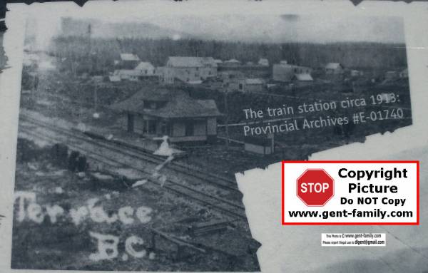
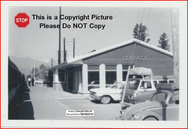
Terrace Station
The first date a train belonging to the Grand Trunk Pacific Railway passed through Terrace from the East arriving in Prince Rupert at 1:15pm April 9, 1914.

Train Station 1913
Photo from a Historical Info stand on Terrace Grand Trunk Pathway

94.6 mi from Prince Rupert
Elevation- 223 ft above sea level
1651.5 miles from Winnipeg

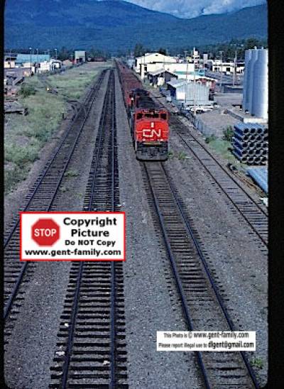
CN Train- July 3, 1982 from Sande Overpass
Little Canyon
Latitude- 54º 31' 0“ N, Longitude- 128º 33'30” W
Little Canyon
Note- This was NOT named after George Little.
It is Little as opposite of Large.
It is located where the Old Skeena Bridge is located.
The Government actually blew up some of the rocks in the channel to make it easier for the Sternwheelers to navigate.
Ring bolts exist in the rocks here.
Eddy Station (in 1911 list)
(located at mile 94.32 in 1911)
Strange part this name was moved to a station on the Fraser river, just SE of McBride.
It never became official at this spot.
Stuarts (Stewarts?) / Dobies
Stuart's Landing
Copper River Station (in 1911 list)
located at mile 100.29 in 1911
Vanarsdol (Van Arsdol) Station
108 mi from Rupert
Elevation- 239 ft above sea level
1645.9 miles from Winnipeg
Usk Station
107 mi from Rupert
Latitude- 54º 38' N, Longitude- 128º 25' W
Elevation- 294 ft above sea level
1638.9 miles from Winnipeg
Hanall Point
aka- Hanall Spur
110.5 miles from Rupert
Railway flag stop, 3 1/2 miles from Usk
Name was formed Royal Lumber Company Sawmill owner, Ole Hanso,n and partner Bob Allen
Pitman Station
115 mi from Rupert
Latitude- 54º 42' N, Longitude- 128º 19' W
Elevation- 344 ft above sea level
1632.2 miles from Winnipeg
Flag Station
Located at mouth of St. Croix Creek
Unincorporated area
Named after William Pittman Litt Hinton
Vice-President and GM of the GTPR
Pacific Station / Nicholl Station
120 mi from Rupert
Latitude- 54º 46' N, Longitude- 128º 15' W
Elevation- 372 ft above sea level
1626.7 miles from Winnipeg
First Divisional Point on the GTP
Government Telegraph Station.
Railroad Round houses, Machine shops etc.
Originally called Nicholl Station
Nicholl named after the Superintendent at the Pacific Terminus,
George Alexander McNicholl
It was the First Divisional Point
Thunder Creek (Water)
Elevation- 389 ft above sea level
1623.5 miles from Winnipeg
Dorreen Station
125 mi from Rupert,
Latitude- 54º 50' 35“ N, Longitude-128º 20' 41” W
Elevation- 412 ft above sea level
1620.6 miles from Winnipeg
Located at mouth of Lorne Creek
Dorreen named after Mr. Ernest James Dorreen, Resident Civil Engineer on the GTP Railway
Fiddler Creek (Water)
Elevation- 437 ft above sea level
1620.0 miles from Winnipeg
Lorne Creek (Water)
Elevation- 461 ft above sea level
1617.2 miles from Winnipeg
Henry McDame discovered gold here in 1884
Ritchie Station
132 mi from Rupert
Latitude- 54º 55' N, Longitude-128º 23' W
Elevation- 457 ft above sea level
1614.1 miles from Winnipeg
See Ritchie page for 2 suspects for where name came from
Porcupine Creek (Water)
Elevation- 464 ft above sea level
1612.7 miles from Winnipeg
Mosquito Creek (Water)
Elevation- 489 ft above sea level
1608.3 miles from Winnipeg
Meanskinisht / Cedarvale Station
140 mi from Rupert
Latitude- 55º 1' 10“ N, Longitude- 128º 19' 45” W
Elevation- 502 ft above sea level
1605.7 miles from Winnipeg
Hollwood station
shown opposite Meanskinisht, on the Skeena River
Woodcock Station
146 mi from Rupert,
Latitude- 55º 4' N, Longitude- 128º 14' W
Elevation- 537 ft above sea level
1600.3 miles from Winnipeg
Flag Station
Ksiden Creek (Water)
(spelling?)
Elevation- 554 ft above sea level
1598.8 miles from Winnipeg
Getwinskowl River (Water)
(spelling?)
Elevation- 561 ft above sea level
1594.7 miles from Winnipeg
Gitwangar / Kitwanga Station
153 mi from Rupert,
Latitude- 55º 6' N, Longitude- 128º 4' W
Elevation- 584 ft above sea level
1592.7 miles from Winnipeg
Government Telegraph Station
Andimaul Station
158 mi from Rupert
Latitude- 55º 6' N, Longitude- 127º 57' W
Elevation- 659 ft above sea level
1588.1 miles from Winnipeg
Nash Station
1 1/2 mi west from Skeena Crossing
Elevation- 744 ft above sea level
1583.4 miles from Winnipeg
1921 Steve Bodnar was CNR Section foreman at Nash
b- age 27 in 1921, in Austria
Harry Nubrey was his Section Hand
b- age 54 in 1921 in Austria
both immigrated in 1910
The railroad from Prince Rupert to here is on the North side of the Skeena River
At Skeena Crossing a huge 961 ft long, a steel bridge was built to cross the Skeena here, and after that the rails run on the south side of the Skeena.
Canadian Bridge Company Ltd. of Walkerville, ON built the bridge, the same company that built the Cambie St. Bridge in Vancouver.
2 concrete piers in the river had to be built, plus 2 more of shorter height on the river banks.
J. E. Beauchamp was GTP Agent here in 1912
Skeena Crossing (Mine Spur)
163 mi from Rupert
Latitude- 55º 5' 55“ N, Longitude- 127º 48' 40” W
Elevation- 743 ft above sea level
1582.1 miles from Winnipeg
Oct 1913 made into a Flag Station
located at foot of Rocher De Boule Mountain
Carnaby Station
Latitude- 55º 10' N, Longitude- 127º 46' W
Elevation- 851 ft above sea level
1576.2 miles from Winnipeg

