Lignite Coal Mines Ltd
Pinto, Saskatchewan, Canada
Old Abandoned Underground Coal Mines can be Very Dangerous, Due to Collapse, and Mine Gases (Noxious and Flammable).
Extreme Care should be taken around them, due to Falls, Sudden Ground Collapse, and Bad Air, and in NO Circumstances should People enter into ANY Mine Openings, or Associated Caves.
The Material Contained on my Sites, is NOT to Encourage Personal Investigation of these Mines, But only as a Historical Record of these Long Abandoned Mines. Please View these Mines from a Far, Safe and Legal Distance. Always Observe Private Property Rights, and Obey ALL Warning Signs.
You can dismiss this warning with the x in the top right.
Lignite Coal Mines Ltd.
aka: Lignite Mines Ltd.
aka: South Cambrian Ltd.
aka: South Cambrian Coal Company Ltd.
7 Ft. Lignite Coal Seam
CPR Coal Mine Leases Nos 217 and 218
All of Section 1, Township 2, Range 6, W2, and LSD8, and NE 1/4 Section 35, Township 1, Range 6, W2
South Cambrian Cobble Lump Coal sold in Regina Nov 1944 for $6.30 a ton.
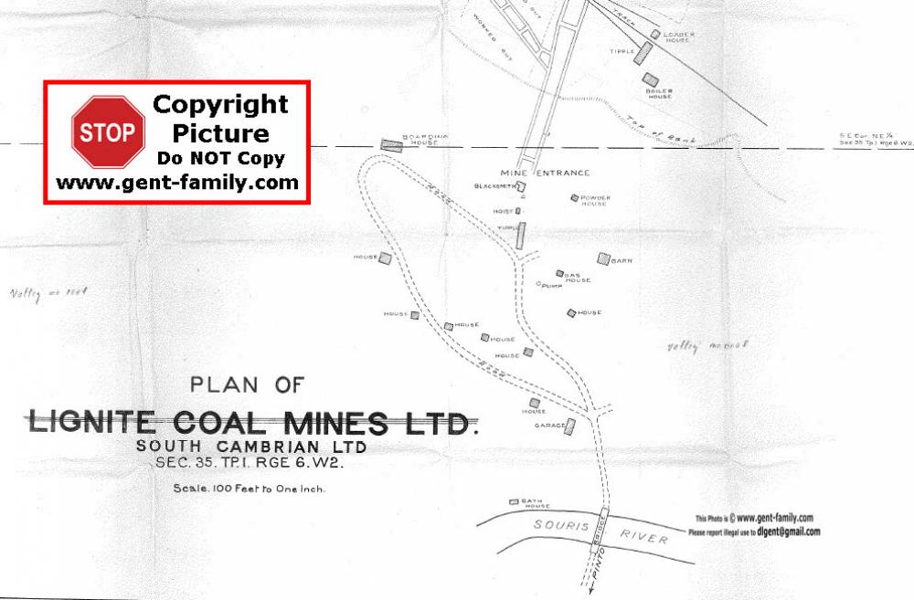
A Very Big Underground Mine, Located North Side of Souris River, all North of Pinto SK.
Mine located SE Corner, NE 1/4 Section 35, Township 1, Range 6, W2
Surveyed June 18, 1932 by Robert John Campbell Lee, RPE
Credit
Mine Plan Documents and maps above, copied from Original Documents, held by Saskatchewan Government, Mines Branch, Regina,
Acquired by Richard (Dick) Wright, P. Eng, and contributed by Mr. Wright for viewing here.
He was assured they were Public Documents, and Web Use allowed.
Info below from my Original Coal Mine Index page
South Cambrian Coal Company Ltd.
Operating in 1937
By Dec 8, 1945 they had an agreement with District 18, U.M.A., (United Mine Workers of America)
June 5, 1946 they signed a wage agreement with the UMWA, District 18
Jan 1, 1949, after a strike starting Nov 3, 1948 David Wholley, (Woolley?) Estevan Manager of this mine,
Announced the mine would close, all equipment,, and mine buildings sold, or moved off the property.
It was an underground mine that employed 40 men, half of whom lived on the property.
Lignite Mines Ltd.
Located SE of Western Dominion Coal Mines
Township 1, Range 6 -W2
Oct 1924 map showing mine location
headed by Hugh Roberts Oct 1, 1924 this Company was one of the sponsors of the First Air Mail flight in Saskatchewan, from Estevan to Winnipeg.
Oct 1924 article on this mine Article also stated they were building cottages and that they controlled 1,000 acres of proved coal land
They sold the coal by the name of “Hy-Power Coal”
©

