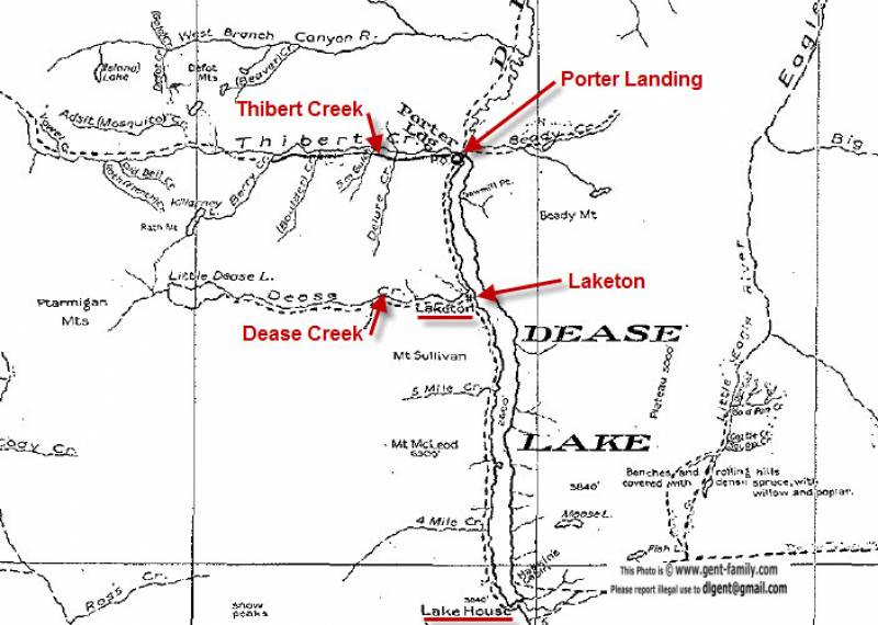
Porter Landing
Porter Landing, British Columbia, Canada
Porter Landing
in the “Cassiar” Land District
Originally this was First Nation “Kaska” aka “Casca” Reserve area
They are related to the Tahltan.
Later the name was changed to “Cassiar”
Near the mouth of Thibert Creek
Lat- 58º 48' N,
Long- 130º 6' W
Unincorporated Area
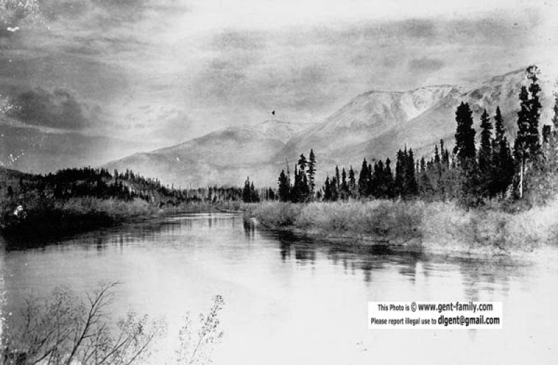
Looking up Dease River, June 19, 1887
Credit: George M. Dawson/Library and Archives Canada/PA
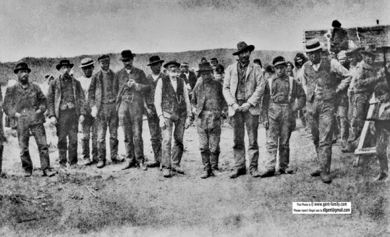
Combined Surveying Crews, Dease River, ca 1887
Credit: George M. Dawson/Library and Archives Canada/PA
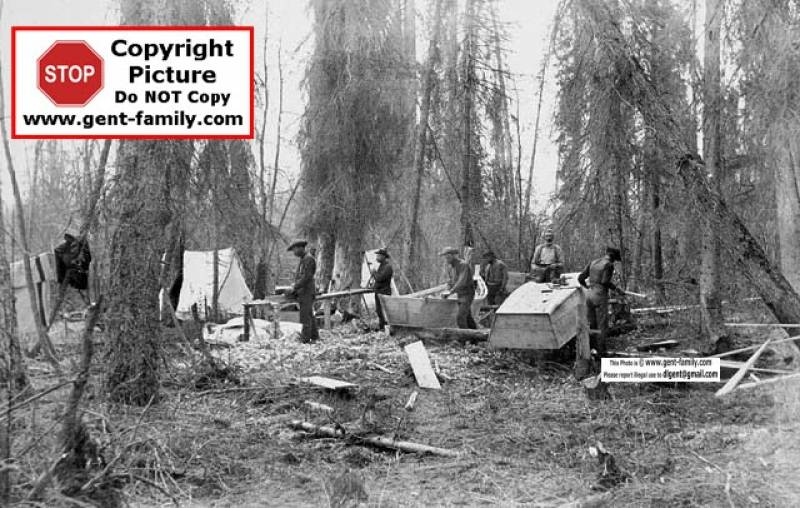
Boat Building Dease Lake, June 1887
Credit: George M. Dawson/Library and Archives Canada/PA
Gold Commisioner John Howe Sullivan was appointed, ca June 1874, when the Provincial Mines Department was formed.
John Howe Sullivan
b-
d- Nov 4, 1875, Cape Flattery, WA
He died on the sinking of the SS Pacific,
sailing from Victoria to San Francisco.
He was a Police Constable in 1864 in Quesnel
He was a Judge before becoming Gold Commissioner.
He was charged with shooting with intent, and wilful murder in 1873.
A. W. Vowell took over from him, after his death.
Mt. Sullivan in map above, named after this man.
Feb 1878,
A. W. Vowell, Gold Commissioner at Laketon BC
His 1881 salary was $2,000 /yr
Vowell Creek named after this man, 14 miles from Laketon
Shown top left of map above off Thibert Creek
Arthur Wellesley Vowell
b- Sept 17, 1841 in Tipperary, Ireland
d- Sept 26, 1918 in Victoria BC, age 79
son of Richard Prendergast Vowell
Came to BC in Feb 1862
see Bio link below
ca 1884 and 1897
- James Porter-
Mining Recorder, Gold Commissioner, and Post Office, at Laketon
James Porter
b- Mar 14, 1851 in England
d- Dec 30, 1926 in Victoria, age 75
Shown as Hotel Keeper in Cassiar District in 1881
Came to BC as a child in 1853
Crown Land Grant, Cassiar, #2402, July 7, 1905
Porter Landing was 7 miles away from Laketon, at North end of Dease Lake
A Trading Post named after James Porter
see map above
(Porter Landing Photo link below)
It was located at mouth of Thibert Creek
Thibert Creek Named after Henri Thibert
Henri (aka: Henry) Thibert
b- Feb 8, 1845, St. Celement, Beauharnois, Quebec, (age 46 in 1891)
d- Mar 16, 1900, (in Quebec probably), age 55
buried in St-Étienne-de-Beauharnois, Québec, Mar 19, 1900
1891 he was still in the Stickeen area, age 46, Gold Miner.
son of Jean Baptiste Thibert (1806-1862)
and Catharine Menard (1817-1900)
He was back in Quebec in 1881
with his mother, and 3 siblings
sister- Catherine Thibert, age 42 in 1881
brother- Octave Thibert, Age 27 (see below)
brother- Joseph Thibert, age 22
all born in Quebec
all 3 brothers shown as Voyageurs
Henri Thibert was the first to Discover Gold in the Cassiar District
ca: late May, 1873
It was actually a man in his party,
but he was the leader of the party, therefore got the credit for it.
He came from Beauharnois, near Montreal
He emigrated first to Minnesota USA.
Apr 20, 1869 he left Caulysville, Minnesota,
down the Red River to Winnipeg.
It took him 10 days.
He stayed for 40 days there.
He met a miner Henry Nokingus,
Who had just came from the Peace River,
And they joined in an expedition to the McKenzie river.
They started out June 8, 1869.
They crossed the plains with a horse and cart.
Crossed the Saskatchewan River at Fort Cotton.
Proceeded to Lake La Biche, about 1100 mi from Red River.
It took them 43 days to get there.
Here there was a HBC Fort, a Christian Mission station, and a few settlers
They remained for 13 days and built a boat there.
They crossed the lake, and went down the river,
That took them to Athabaska Lake.
They rested a day at the Hudson's Bay Co's Fort there.
Aug 29, 1869 they entered the Peace River.
They descended that River to Great Slave Lake.
Continued on to the mouth of the Hay River,
where they found another HB Post.
Stayed there for 10 days, leaving Oct 10, 1869.
They reached the McKenzie River.
Went down river for 30 miles, then built a cabin for winter.
In the spring they went back to prospect the Great Slave Lake area.
Here they met McCulloch, (McCullough) who had made discoveries in that area.
All of them stayed at Fort Providence for the rest of the winter.
In Feb. Nokingus set out for the Athabaska,
Enroute for the Red River, with a 4 dog sled.
Thibert and McCulloch resolved to give the Liard River (Deloire) a trial.
They built a new boat, June 1, 1871,
They left for Fort Simpson on the McKenzie River.
At Fort Simpson they acquired provisions.
They went upstream until they reached an abandoned fort. (Fort Halkett)
They spent the winter about 12 miles from the river here.
Proceeding on the river they were prospecting as they went.
They sought Dease lake, by way of Dease River.
Here they met 3 Natives. They crossed over to the Stikeen River,
Accompanied by the 3 Natives.
7 days travel brought them to Buck's Bar. (see my Glenora Page)
This was Oct 2, 1872.
McCulloch (McCullough) left for Victoria, and Thibert remained to prospect.
He met 2 French Canadians, and returned to the diggings on Dease lake.
On May 1, 1873 they went up a creek, and got 12 cents to the pan in gold.
Returning to camp they went to work on their boat.
On May 25 1873 they started back for the creek, made a rocker,
and got to work. This Creek became known as Thibert Creek.
They made $10-20 a day each.
News of McCulloch's (McCullough's) death reached them.
McCulloch (McCullough) had froze to death a short way up the Stikeen, in Feb. 1873
In August, 1873, his partner, T. Tailfer, got sick and died.
He was the last one of Thibert's party.
Thibert and H. Lozon were appointed trustees of Tailfer's estate.
Partners from another old paper, Xavier Loayon, and T. Telfair
Loozon and Tifair in another book.
Xavier Lozon
b- ca 1823 in France, age 58 in 1881 in Cassiar district
d-
William Waldron took out the largest nugget from Thibert Creek, weighing 3 1/2 oz
Thibert took out the 2nd largest.
Another source says Thibert and McCulloch (McCullough) travelled up the Liard, and found the First gold in the District, at what became McCulloch's (McCullough's) Bar.
Either way they were the important men in this discovery
this source says both men left to Victoria by way of the Stickeen.
On the way back in the spring, McCulloch (McCullough) died, at what was known as the Desert on the Stickeen.
His name was Angus McCulloch (have seen spelling of McCullogh as well)
He died ca Jan 23, 1873, 8 miles from the mouth
of the Stickeen river, in Alaska territory.
He spent 7 years prospecting before returning to civilization.
He came down to Victoria on the steamer Maude
He left with black hair, and returned with white hair.
He started his travels at the boat encampment on the Columbia river.
through the Rockies to the Athabaska River.
worked his way across the Deloire River to the north branch
Francis Lake. travelled 200 miles to Dice Lake where he camped.
when he went to Victoria he was asking for government help,
for supplies and provisions to help get the gold out of this area.
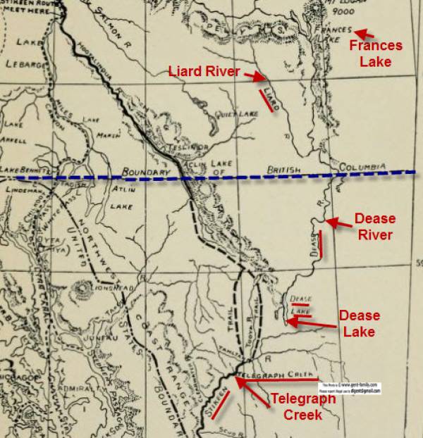
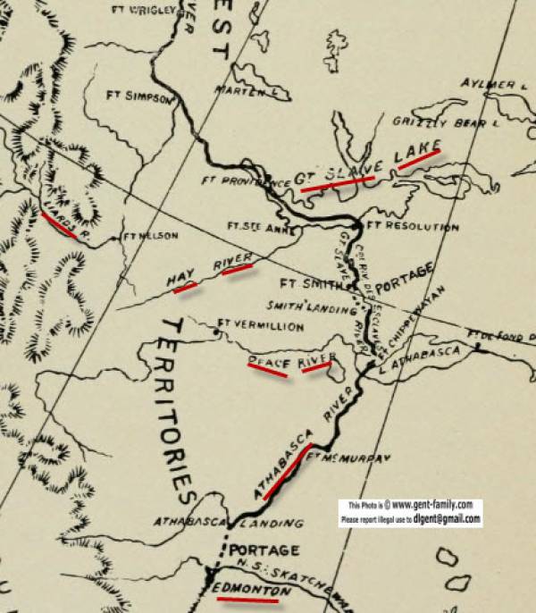
Maps showing places Thibert and others travelled
Sept 1, 1885
James Porter, Hotel Keeper at Porter Landing
J. Porter sold out to the Diamond C Company, ca Sept 1890
Sept 1, 1885 on Thibert Creek
- Hugh Campbell, Miner
- Francois Chelafour, Miner
- John R. Cameron, Miner
- John Carr, Miner
- John Defot, Miner (see Defot page)
- James Dickenson, Miner
- William Foster, Miner
- Joseph Florent, Miner
- James Anderson Gardner, Miner
- William Houghton, Miner
Thomas Harvey, Miner
b- Ireland, age 77 in 1891
- Richard Hughes, Miner
- Joseph Humphries, Miner
- William R. Jones, Miner
- John Kearns, Miner
- Thomas Lafond, Miner
- Donald McDonald, Miner
John McCabe, Miner
b- Ireland, age 54 in 1891
- George McCawley, Miner
- Daniel McVicker, Miner
- William McPherson, Miner
- Peter Ollier, Miner
- William Padham, Miner
- Daniel Parry, Miner
- Robert Reid, Miner
Benjamin Leader Sullivan, Miner
b- Ireland, age 44 in 1891
Stewart Smith, Miner (Stuart Smith),
b- Ireland, age 62 in 1891, married
Henri (aka Henry) Thibert, Miner (see above)
Octave Thibert, Miner
Octave was Henri's brother
b- In Quebec, age 27, in 1881
Andrew Tolmie, Miner
John T. Williams, Miner
Omsciene Delile, Blacksmith
James James, Boatman
Ext Links
not my sites
James Porter Photo, BC Archives
http://www.bcarchives.gov.bc.ca/cgi-bin/www2i/.visual/img_med/dir_146/h_00372.gif
Vowell Bio
http://www.ourroots.ca
his photo, BC Archives
http://www.bcarchives.gov.bc.ca/cgi-bin/www2i/.visual/img_med/dir_102/a_02513.gif
Porter's landing photo, BC Archives
http://www.bcarchives.gov.bc.ca/cgi-bin/www2i/.visual/img_med/dir_124/d_08991.gif
Thibert Creek
http://www.bcarchives.gov.bc.ca/cgi-bin/www2i/.visual/img_med/dir_116/c_07562.gif
http://www.bcarchives.gov.bc.ca/cgi-bin/www2i/.visual/img_med/dir_68/a_02091.gif
http://www.bcarchives.gov.bc.ca/cgi-bin/www2i/.visual/img_med/dir_69/a_05318.gif
http://www.bcarchives.gov.bc.ca/cgi-bin/www2i/.visual/img_med/dir_70/a_07010.gif
http://www.bcarchives.gov.bc.ca/cgi-bin/www2i/.visual/img_med/dir_74/c_07567.gif
http://www.bcarchives.gov.bc.ca/cgi-bin/www2i/.visual/img_med/dir_74/c_07568.gif
